
Google Map开发Android地图应用 图片看不了?点击切换HTTP 返回上层
下面通过一个实例完成一个简单的定位系统,并且在地图上显示当前的位置,实例的详细代码在 GPSLocationInMapDemo 项目中,实际调试时需要在真机上进行并且需要开启 GPS。运行效果如图 1 所示。
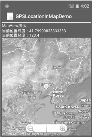
图 1 一个简单的定位系统
具体步骤如下:
1)创建一个新的工程并命名为 GPSLocationInMapDemo。
需要注意的是,由于要使用 Google Map API,因此创建的主 Activity 需要继承自 MapActivity,而不是 Activity。当选择 Build Target 时,应选择 Google APIs,如图 2 所示。
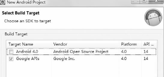
图 2 New Andriod Project 对话框
2)在 AndroidManifest.xml 文件中的 <application> 标签中加入:
在 main.xml 布局中放置了两个 TextView 和一个 MapView 组件。
GPSLocationInMapDemoActivity.java 的代码如下:
MapView 组件通过网络载入所需地图,并且提供了拖曳地图的接口,用户可以直接在 MapView 中移动地图。MapView 提供了地图控制器,通过

图 3 缩放条
Overlay 是 Google Map API 提供的专门在地图上进行标记的类。本实例中使用 Overlay 标记当前的位置点。相关代码为:
至此,该实例开发完成。运行该实例需要支持 Google APIs 的 AVD,如图 4 所示。若没有,则可以通过 AVD Manager 创建一个。
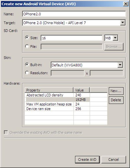
图 4 创建支持 Google APIs 的 AVD
图 1 一个简单的定位系统
1)创建一个新的工程并命名为 GPSLocationInMapDemo。
需要注意的是,由于要使用 Google Map API,因此创建的主 Activity 需要继承自 MapActivity,而不是 Activity。当选择 Build Target 时,应选择 Google APIs,如图 2 所示。
图 2 New Andriod Project 对话框
2)在 AndroidManifest.xml 文件中的 <application> 标签中加入:
<uses-library android:name="com.google.android.maps" />
以便可以使用 Google Map API。为了使用 GPS 数据,在 <application> 标签之外加入如下权限:<uses-permission android:name="android.permission.ACCESS_FINE_LOCATION" />
为了从 Internet 获取地图数据,需要网络访问权限:<uses-permission android:name="android.permission.INTERNET"/>
3)编写 main.xml 布局文件,具体代码如下:1 2 3 4 5 6 7 8 9 10 11 12 13 14 15 16 17 18 19 20 21 22 23 24 | <?xml version="1.0" encoding="utf-8"?><LinearLayout xmlns:android="http://schemas.android.com/apk/res/android" android:layout_width="fill_parent" android:layout_height="fill_parent" android:orientation="vertical"><TextView android:layout_width="fill_parent" android:layout_height="wrap_content" android:text="string/hello" /><TextView android:id="@+id/myLocationText" android:layout_width="fill_parent" android:layout_height="wrap_content"/><com.google.android.maps.MapView android:id="@+id/myMapView" android:layout_width="fill_parent" android:layout_height="fill_parent" android:apiKey="OrvIRrEPTuYsUXACd_p53h-ftI7T425PToOjKuQ" android:clickable="true" /></LinearLayout> |
GPSLocationInMapDemoActivity.java 的代码如下:
1 2 3 4 5 6 7 8 9 10 11 12 13 14 15 16 17 18 19 20 21 22 23 24 25 26 27 28 29 30 31 32 33 34 35 36 37 38 39 40 41 42 43 44 45 46 47 48 49 50 51 52 53 54 55 56 57 58 59 60 61 62 63 64 65 66 67 68 69 70 71 72 73 74 75 76 77 78 79 80 81 82 83 84 85 86 87 88 89 90 91 92 93 94 95 96 97 98 | package introduction.android.gpsLocationInMapDemo;import android.content.Context;import android.location.Location;import android.location.LocationListener;import android.location.LocationManager;import android.os.Bundle;import android.widget.TextView;import com.google.android.maps.GeoPoint;import com.google.android.maps.MapActivity;import com.google.android.maps.MapController;import com.google.android.maps.MapView;import com.google.android.maps.MyLocationOverlay;public class GPSLocationInMapDemoActivity extends MapActivity { /** * Called when the activity is first created. */ // 定义Location对象 protected Location location; //定义MapView对象 private MapView map; // 定义MyLocationOverlay 对象,在地图上标注当前位置 private MyLocationOverlay myLocation; private MapController mapController; private TextView myLocationText; private GeoPoint geopoint; private double latitude; private double longitude; /** * Called when the activity is first created. */ protected boolean isRouteDisplayed() { return false; } public void onCreate(Bundle savedInstanceState) { super.onCreate(savedInstanceState); setContentView(R.layout.main); myLocationText = (TextView) findViewById(R.id.myLocation_Text); //定义 LocationManager对象 LocationManager locationManager; String seviceName = Context.LOCATION_SERVICE; // 获取LocationManager对象 locationManager = (LocationManager) getSystemService(seviceName); locationManager.requestLocationUpdates(LocationManager.GPS_PROVIDER, 2000, 10, locationListener); // 得到MapView对象 map = (MapView) findViewById(R.id.myMapView); //得到MapView对象的控制器 mapController = map.getController(); //设置 map 支持缩放工具条 map.setBuiltInZoomControls(true); map.setSatellite(true); } //得到LocationListener对象 private final LocationListener locationListener = new LocationListener() { //当Provider处于不能使用时触发 public void onProviderDisabled(String provider) { } //当状态发生改变时触发 public void onStatusChanged(String provider, int status, Bundle extras) { } //当位置发生变化时触发 @Override public void onLocationChanged(Location location) { // TODO Auto-generated method stub // 得到当前位置的纬度 latitude = location.getLatitude(); //得到当前时间的经度 longitude = location.getLongitude(); geopoint = new GeoPoint(new Double(latitude * 1E6).intValue(), new Double(longitude * 1E6).intValue()); mapController.setCenter(geopoint); //得到当前时间的MyLocationOverlay对象 myLocation = new MyLocationOverlay( GPSLocationInMapDemoActivity.this, map); myLocation.enableMyLocation(); // 将当前位置添加到地图上 map.getOverlays().add(myLocation); //设置地图为卫星模式 myLocationText.setText("当前位置纬度" + latitude + "\n当前位置经度" + longitude); } //当Provider处于可用时触发 @Override public void onProviderEnabled(String provider) { // TODO Auto-generated method stub } };} |
mapController=map.getController();
方法可以获取到。通过控制器可以方便地控制 MapView 组件中地图的缩放和窗口移动。本实例中通过mapController.setCenter(geopoint);
控制器将当前位置 geopoint 设置为 MapView 组件的中心。GeoPoint 代表的是地图上特定的点,需要注意的是,在 MapView 中使用的 geoPoint 的经纬度位置与从 GPS 中获取的经纬度存在一个 1E6 的比例差,需要经过转换后才能正确显示当前位置。本实例中的坐标转换代码为:
latitude = location.getLatitude();
longitude = location.getLongitude();
geopoint = new GeoPoint(new Double(latitude * 1E6).intValue(), new Double(longitude * 1E6).intValue());
map.setBuiltInZoomControls(true);
在地图上放置一个缩放条(如图 3 所示),用户可以直接使用该缩放条对地图进行放大和缩小,而无须编写任何代码。图 3 缩放条
Overlay 是 Google Map API 提供的专门在地图上进行标记的类。本实例中使用 Overlay 标记当前的位置点。相关代码为:
1 2 3 4 5 | //得到当前时间的MyLocationOverlay对象myLocation = new MyLocationOverlay(GPSLocationInMapDemoActivity.this, map);myLocation.enableMyLocation();// 将当前位置添加到地图上map.getOverlays().add(myLocation); |
图 4 创建支持 Google APIs 的 AVD